Showing posts with label SRTM. Show all posts

Saturday, October 28, 2006

USGS Seamless data server

In a recent reminder from sommeone at the USGS, I have to admit that I have neglected to promote this fabulous data resource. Most users know about it (or should know about it), therefore, as a result it sometimes gets forgotten. Thing of the seamless data distribution system as the grand-daddy of the USGS geospatial repositories... and then some! This site has complete coverage of theNational Elevation Dataset that supercedes Digital Elevation Models, complete DOQQcoverage, over 30 Tb of urban imagery, one-time coverage of full resolution Landsatimagery, and much more. Also, the data are seamless, so you can put a box aroundthe data without having to figure out quadrangles and then having to assemble themall. Here's some details from our friends at the USGS if you need to hear more...
Free downloads are availble - up to 1.6 Gbytes of data in 100 MB files in one user request. Users have unlimited access to the interactive map and can make unlimited requests.The amount of coverage area depends on the number of products selected for download.For example, if NED 1 Arc Second is selected as the only product a user can downloadup to a 30 square degree area. But, if NED 1 arc second and NED 1/3 arc second areselected, then the area available for download will be considerably smaller. To seethe various sizes of coverage area for each product, click on the List of Productsdrop down, select the desired product. User can define an area of interest by drawing a box, defining coordinates, or useavailable templates to cut out the area. The first method of drawing a box (square or rectangle) is best for defining ageneral area. The coordinates are displayed, in decimal degrees, in the bottom leftcorner of the window as the mouse is moved over the map. The second method ofdefining coordinates can be used when the user wants a precise area and knows thecorner coordinates. The third method is the use of provided templates, such as 7.5min quadrangles. Bookmark this one, or maybe even set it as your homme-page! http://seamless.usgs.gov/

Share/Bookmark

Saturday, October 21, 2006

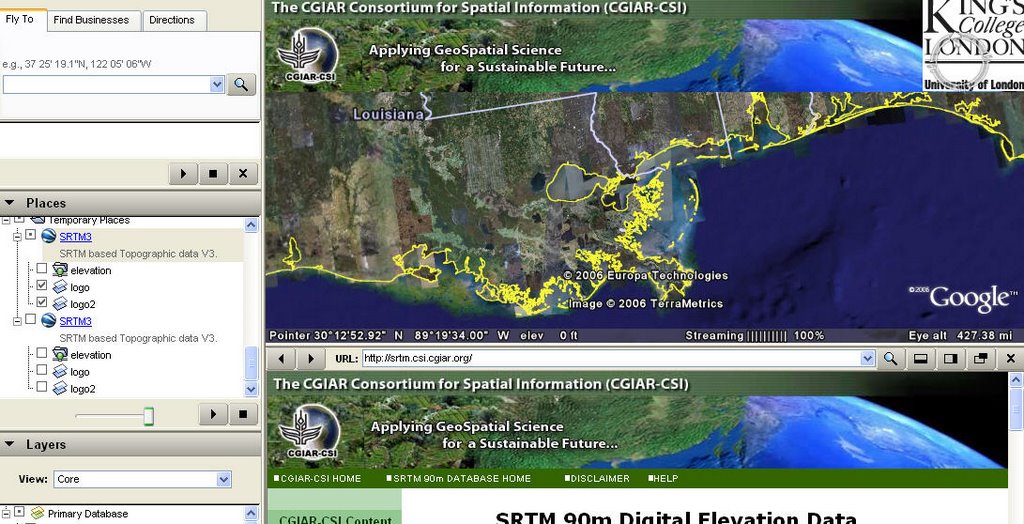
Processed SRTM 90m Digital Elevation Data (DEM) in Google Earth

Looking to view the SRTM data within Google Earth... see http://www.ambiotek.com/topoview (this will launch G Earth) - To use simply Fly To your location and click the nearest waypoint. You will then see a balloon which allows you to preview or download the five degree tiles of data. More documentation at http://srtm.csi.cgiar.org/
Share/Bookmark

DG-ADV SRTM30 Download Site

Are you still paying for SRTM DEM data??? Don't be stupid man, check out this resource! Click on the SRTM30 tile to download the Digital Elevation Map (DEM) from the place you select. All the links will download the data from the USGS site: ftp://e0mss21u.ecs.nasa.gov/srtm/srtm30 - see the UI ast http://www.dgadv.com/srtm30/
Share/Bookmark

FREE 30-arc-second elevation data

This site provides FREE 30-arc-second elevation data with bathymetry for the entire world. The data was created based on the SRTM-30 data set, then holes were filled with GTOPO-30 data and bathymetry from various sources was used to replace the ocean areas. This data consists of 33 files of global topography in the same format as the SRTM30 products distributed by the USGS EROS data center. The grid resolution is 30 second which is roughly one kilometer. see http://topex.ucsd.edu/WWW_html/srtm30_plus.html of jump to the FTP server at ftp://topex.ucsd.edu/pub/srtm30_plus
Share/Bookmark

Friday, September 22, 2006

Processed SRTM 90m Digital Elevation Data (DEM) for the Entire Globe

The CGIAR-CSI GeoPortal is now serving up processed SRTM 90M Global DEM data. Digital elevation models (DEM) for nearly the entire globe, covering most of the countries of the world, are available for download on this site. The SRTM 90m DEM's have a resolution of 90m at the equator, and are provided in mosaiced 5 deg x 5 deg tiles for easy download and use. All are produced from a seamless dataset to allow easy mosaicing. These are available in both ArcInfo ASCII and GeoTiff format - see http://srtm.csi.cgiar.org
Share/Bookmark

Saturday, September 16, 2006

SRTM DTED Level 2 - 1 arc second data

Shuttle Radar Topography Mission DTED® Level 2 (1 arc second) Data on DVD (United States and Territorial Islands) -- SRTM DTED® is a uniform matrix of elevation values indexed to specific points on the ground. The horizontal datum is the World Geodetic System 1984 (WGS84) and the vertical datum is mean sea level as determined by the WGS84 Earth Gravitational Model (EGM 96) geoid. The elevation data are with respect to the reflective surface, which may be vegetation, man-made features or bare earth. DTED® Level 2 elevation values are spaced one arc second apart between 0 degrees and 50 degrees latitude, and spaced one arc second apart in latitude and two arc seconds apart in longitude between 50 degrees and 60 degrees latitude. SRTM DTED® Level 1 values are derived from the SRTM DTED® 2 values such that the DTED® 1 values are identical to the DTED® 2 values at coincident points. However, the SRTM DTED® 1 values are spaced 3 arc seconds apart between 0 degrees and 50 degrees latitude, and spaced 3 arc seconds apart in latitude and 6 arc seconds apart in longitude between 50 degrees and 60 degrees latitude. These data are now available on a cost recovery basis and can be ordered on CD-ROM for a mere $60 per CD http://edcsns17.cr.usgs.gov/srtmdted2/ See also the level 1 - 3 arc second Global data product http://edcsns17.cr.usgs.gov/srtm/
Share/Bookmark