Tuesday, October 31, 2006
State and Metropolitan Area Data Book
A reminder about a very useful, new resource from the Census Bureau... The State and Metropolitan Area Data Book features more than 1,500 data items for the United States and individual states, counties and metropolitan areas from a variety of sources. The files include data published for 2005 population and housing unit estimates and many items from the 1990 and 2000 Census of Population and Housing. Information in the State and Metropolitan Area Data Book covers the following topical areas: age, agriculture, births, business establishments, communications, construction, cost of living, crime, deaths, education, elections, employment, energy, finance, government, health, households, housing, immigration, income, manufactures, marriages and divorces, media, natural resources, population, poverty, race and Hispanic origin, residence, retail sales, science and engineering, social services, tourism, transportation, and veterans. See the complete publication here - http://www.census.gov/prod/2006pubs/smadb/smadb-06.pdf (PDF) or http://www.census.gov/compendia/smadb/

Monday, October 30, 2006
GIS Data Search Engine withg 1900 more links indexed
Recall last week I made mention of the Google Co-op API and the new functionality that enables users (like me) to create their very own search engine. Since that time I've added some 1900+ of my favorite GIS resources (mostly data resources) which has resulted in a customized search tool that yields some awesome results if I say so myself! Many of the links come submitted directly to me for inclussion in vary sections at GISuser.com (ie. link section, free data resources, state clearinghouses etc...) Check it out and be sure to drop me a line if you don't think your favorite data resource is listed yet See the GIS Data search Engine HERE
Saturday, October 28, 2006
USGS Seamless data server
 In a recent reminder from sommeone at the USGS, I have to admit that I have neglected to promote this fabulous data resource. Most users know about it (or should know about it), therefore, as a result it sometimes gets forgotten. Thing of the seamless data distribution system as the grand-daddy of the USGS geospatial repositories... and then some! This site has complete coverage of theNational Elevation Dataset that supercedes Digital Elevation Models, complete DOQQcoverage, over 30 Tb of urban imagery, one-time coverage of full resolution Landsatimagery, and much more. Also, the data are seamless, so you can put a box aroundthe data without having to figure out quadrangles and then having to assemble themall. Here's some details from our friends at the USGS if you need to hear more...
Free downloads are availble - up to 1.6 Gbytes of data in 100 MB files in one user request. Users have unlimited access to the interactive map and can make unlimited requests.The amount of coverage area depends on the number of products selected for download.For example, if NED 1 Arc Second is selected as the only product a user can downloadup to a 30 square degree area. But, if NED 1 arc second and NED 1/3 arc second areselected, then the area available for download will be considerably smaller. To seethe various sizes of coverage area for each product, click on the List of Productsdrop down, select the desired product. User can define an area of interest by drawing a box, defining coordinates, or useavailable templates to cut out the area. The first method of drawing a box (square or rectangle) is best for defining ageneral area. The coordinates are displayed, in decimal degrees, in the bottom leftcorner of the window as the mouse is moved over the map. The second method ofdefining coordinates can be used when the user wants a precise area and knows thecorner coordinates. The third method is the use of provided templates, such as 7.5min quadrangles. Bookmark this one, or maybe even set it as your homme-page! http://seamless.usgs.gov/
Tuesday, October 24, 2006
GIS data resource search engine
I've been messing around with the new Google custom search today and have created a custom search page for the GISuser website search results. You can access the search page HERE... pleaase feel free to contribute GIS realated websites to be included inn the search spider.
Oregon Geospatial Enterprise Office (GEO)
GEO helps to coordinate GIS activities in the state, facilitates communication about GIS issues, and maintains the website that hosts statewide geospatial data for the State of Oregon, the Oregon Geospatial Data Clearinghouse (OGDC). GEO is primarily funded through an assessment paid by all state agencies. Their mission is simple... To provide statewide leadership in promoting the use of GIS technology and to ensure the availability of easily accessible, high quality geographic information. Many data themes are online in the spatial data library and the library is available to users as a web service (interactive webmap) or a download repository (html). Data themes available include:lakesstreamscensusgeologyDOQDRGPLSSSchool Districts and much more - see http://www.gis.state.or.us/data/alphalist.html
Rhode Island Geographic Information System (RIGIS
The RIGIS mission is to monitor, coordinate, and provide guidance for activities related to the use of geographic information system technology in Rhode Island, to support initiatives to implement or use this technology, and to manage and provide access to a comprehensive database of geographically referenced information. Plenty of data is available including 1:12,000 true color orthophotography from Summer 2003 with a 1 meter pixel resolution. Numerous data themes are available including:
Boundaries (municipal, shoreline, villages)
Coastal resources
Cultural data
Demographic data
Emergency (911)
DEM (30m)
facilities
flood
hydrography
Orthophotos
Access RIGIS at http://www.edc.uri.edu/rigis
Boundaries (municipal, shoreline, villages)
Coastal resources
Cultural data
Demographic data
Emergency (911)
DEM (30m)
facilities
flood
hydrography
Orthophotos
Access RIGIS at http://www.edc.uri.edu/rigis
Saturday, October 21, 2006
Processed SRTM 90m Digital Elevation Data (DEM) in Google Earth
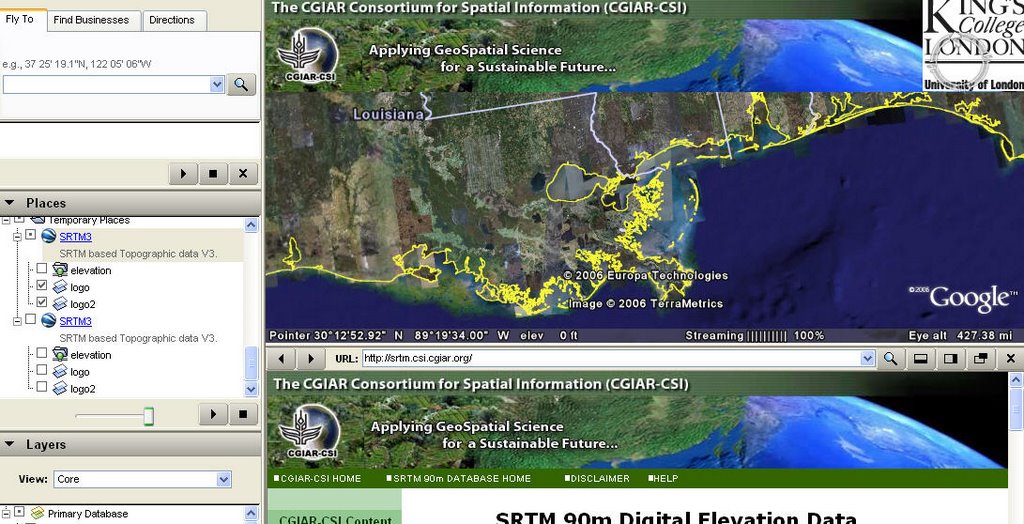 Looking to view the SRTM data within Google Earth... see http://www.ambiotek.com/topoview (this will launch G Earth) - To use simply Fly To your location and click the nearest waypoint. You will then see a balloon which allows you to preview or download the five degree tiles of data. More documentation at http://srtm.csi.cgiar.org/
DG-ADV SRTM30 Download Site
Are you still paying for SRTM DEM data??? Don't be stupid man, check out this resource! Click on the SRTM30 tile to download the Digital Elevation Map (DEM) from the place you select. All the links will download the data from the USGS site: ftp://e0mss21u.ecs.nasa.gov/srtm/srtm30 - see the UI ast http://www.dgadv.com/srtm30/
FREE 30-arc-second elevation data
This site provides FREE 30-arc-second elevation data with bathymetry for the entire world. The data was created based on the SRTM-30 data set, then holes were filled with GTOPO-30 data and bathymetry from various sources was used to replace the ocean areas. This data consists of 33 files of global topography in the same format as the SRTM30 products distributed by the USGS EROS data center. The grid resolution is 30 second which is roughly one kilometer. see http://topex.ucsd.edu/WWW_html/srtm30_plus.html of jump to the FTP server at ftp://topex.ucsd.edu/pub/srtm30_plus
Thursday, October 19, 2006
Search for data using answers.com
This nifty search utility which I confess, I'm not terribly familiar with is very sweet! Check out answers.com for somme very decent results! USers start with a wi-ki style format where you can get very accurate definitions for almost any term. Then use the search utility for somme great leads! http://www.answers.com - As a testbed I search for "alabama gis data" and the utility returns pointers to the following top resources: GSA Geospatial Data Clearinghouse , Alabama Water Quality Information System - Geo-Spatial Data, GIS Data Sets Alabama
Hurricane disaster response GIS data from USGS
The Hazards Data Distribution System from the USGS provides a dynamic online map interface that can be used to view USGS datasets that are part of The National Map as well as specialized data products resulting from the response. FTP links to data sets available for numerous distasters including hurricane Rita, Katrina, Wilma, and others.. interactive map viewers also provided. See http://gisdata.usgs.gov/website/Disaster_Response/
No metadata, no worries... Ya right!
This classic response came through a GIS discussion list recently
regarding accessing data from the datadepot. How's this opener "No one
seemed concerned that DataDepot doesn't include metadata"... Really..
Nobody seems concerned?? Well, if I was paying for the "Free" data I'd
be concerned! In an effort to get metadata for some of the "free" data
the guy bought, he resulted to searching for other resources which
yielded a State resource that provided much more recent imagery plus
metadata.
UTM zone locator tool
If you've ever been in the position where you needed to determine which UTM zone(s) a county falls in this useful resource may be the tool you need. See http://home.comcast.net/~rickking04/gis/spc.htm
DataPlace and My Geographies
DataPlace is a one-stop source for housing and demographic data about your community, your region, and the nation. The site provides easy access to data at geographic scales ranging from the neighborhood to the nation. DataPlace lets you assemble your own geographies by using the My Geography tool. This tool lets you aggregate multiple disparate location types - States, Metros, Cities, Counties, Zips, and/or Tracts - so that you can aggregate across statistics on DataPlace for a set of locations you choose. The site also provides a powerful yet simple mapping tool that allows you to produce colorful thematic maps with just a few clicks of the mouse. See http://www.dataplace.org
Tuesday, October 17, 2006
Minnesota Statewide Transportation Data
From the DOT, loads of freely available data including PLSS boundaries, parks, streams, transportation layers, and much more. Seehttp://www.dot.state.mn.us/tda/basemap/
MetroGIS DataFinder - Minneapolis-St. Paul
DataFinder is a one-stop-shop for discovering geospatial data pertaining to the seven county Minneapolis-St. Paul Metropolitan Area. The resosurce makes available a ton of data freely available via FTP download. Currently, there are metadata for 205 datasets available on the DataFinder site - See http://www.datafinder.org/catalog/index.asp
Thursday, October 12, 2006
Updated - State Data Centers and Clearinghouses
Follow this valuable list of pointers to State GIS Clearinghouse nodes... a nicely updated list compiled by the folks at Montana's NRIS... nice job! Most of these resources contain freely downloadable data products that include DRG, DEM, DOQ, soils data, census products, aerial photography, NED, and more.
- Alabama Geological Survey
- Alaska State Geospatial Data Clearinghouse
- Arizona Geographic Information Council
- Arkansas GIS Gateway
- California Spatial Information Library
- University of Colorado Map Library
- University of Connecticut Map & Geographic Info Center
- Connecticut Dept of Environmental Protection
- Delaware DataMIL
- Florida Geographic Data Library
- Georgia GIS Data Clearinghouse
- Hawaii Statewide GIS Program
- INSIDE Idaho
- Illinois Natural Resources Data Clearinghouse
- Indiana GIS Initiative
- Iowa Geospatial Data Clearinghouse
- Iowa Dept. of Natural Resources
- Kansas Geospatial Community Commons
- Kentucky Office of GIS
- Louisiana MAP
- Maine Office of GIS
- Maryland State Geographic Information Committee
- Massachusetts Geographic Information System
- Michigan Center for Geographic Information
- Minnesota Land Management Information Center
- Mississippi Automated Resource Information System (MARIS)
- Missouri Spatial Data Information Service
- Montana State Library GIS Program
- Nebraska GIS Steering Committee
- Nevada Geographic Information Clearinghouse
- New Hampshire GRANIT net
- New Jersey Geographic Information Network
- New Mexico GIS Resources
- New York State Library GIS Clearinghouse
- North Carolina Center for Geographic Information & Analysis
- North Dakota Geographic Information Systems
- Ohio Geographically Referenced Information Program
- Oklahoma State GIS Council
- Oregon Geospatial Enterprise Office
- Pennsylvania Spatial Data Access
- Rhode Island GIS Data
- South Carolina: USC Data Server
- South Dakota Geological Survey
- South Dakota GIS
- Tennessee GISource
- Texas Natural Resource Information System GIS Data Catalog
- Utah Automated Geographic Reference Center
- Vermont Center for Geographic Information
- Virginia Digital Map Library
- Washington Geographic Information Council
- West Virginia GIS Data Clearinghouse
- Wisconsin Land Information Clearinghouse
- Wyoming GIS Resources
Wednesday, October 11, 2006
Montana Geographic Information Clearinghouse
Gerry from the Montana State Library provided us with an update about this fabulous free data resource for the State of Montana. Downloadable datasets include soils data, DEMs, topos, aerial photography, cadastral data and more. Features of the site include a simple but effective data list, a very cool data bundler, and the topo finder.. bookmark this one! http://nris.mt.gov/gis/
Monday, October 09, 2006
USDA FSGeodata Clearinghouse
The FSGeodata Clearinghouse provides searching, viewing and downloading of geospatial datasets and metadata created and maintained by the USDA Forest Service over lands of the National Forest System. Access to datasets is provided through a user-driven geographic interface. Access various vector and raster data products as well as real-time and near real-time MODIS fire detection GIS data, MODIS fire detection maps, and MODIS imagery. CFF data available include: roads and trails, streams, water bodies, political and administrative boundaries, land ownership, and constructed features - all at 1:24k scale - See http://svinetfc4.fs.fed.us/
Friday, October 06, 2006
Alabama GIS data resources
Looking for Alabama GIS data? Start your search at at Alabama State Clearinghouse (free DRGs) at http://www.gsa.state.al.us/gsa/GIS/clearinghouse.html. Some other useful Alabama county and city GIS Data resources where you can locate freely available GIS data products:
Auburn Autauga Baldwin Blount Calhoun Chambers Clarke Colbert Coffee Cullman DeKalb Elmore Escambia Etowah Franklin Huntsville Lauderdale Lee Limestone Madison Marion Marshall Mobile Morgan Russell St Clair Shelby Tallapoosa Tuscaloosa
Thursday, October 05, 2006
Minnesota ToMO Service
DNR "Tons of Maps Online" or ToMO service. Here you can browse every USGS 1:24,000, 1:100,000 and 1:250:000 quadrangle for Minnesota. This is currently an experimental application at the time of posting. See http://maps.dnr.state.mn.us/tomo/
Minnesota Land Management Information Center
The LMIC has been responsible for developing a strategic plan for the Minnesota GIS - Minnesota's Spatial Data Infrastructure. Recent success stories include the acquisition of 2003 orthoimagery for the entire State (cooperatively funded by the state and the National Aerial Imagery Program of the Farm Services Agency) and they made data available at no cost to users. LMIC maintains the MN Geographic Data Clearinghouse - a LMIC program that serves as a "One Stop" source for geospatial data needed to power Geographic Information Systems. Be sure to see the raster clipping project for DOQQs, NAIP data, and other othophotos... see http://www.lmic.state.mn.us/chouse/index.html - for DRGs see here
Maryland Mapping Resource Guide (MMRG)
The Maryland Mapping Resource Guide (MMRG) provides you with an easy, convenient tool to search and retrieve contact information for Maryland State Geographic Information Coordinating Committee (MSGIC) members, maps and geographic data relating to Maryland, information on GIS and mapping projects, and other resources related to mapping. Links to Open GIS Consortium (OGC) Web map services are available for previewing data via the Web. Data available for viewing in the interactive mapping application from the MSGIC include aerial photos, POIs, census data, protected areas, transportation data, and much more. The application was developed by the CGIS at Towson University. See http://www.marylandgis.net see also http://www.msgic.state.md.us/
Michigan Center for Geographic Information (MCGI)
This site currently contains over 60 unique statewide datasets including the state's basemap (MI Geographic Framework), aerial imagery, geology, hydrography, land ownership, topography, and much more. Please visit often as geographic information from across state government will continually be made available and updated through this portal - See http://www.mcgi.state.mi.us/mgdl/ - Searchable by geography, theme, or meta data.
Subscribe to:
Posts (Atom)